


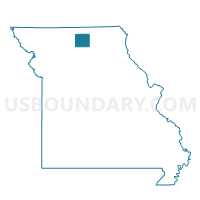
Winigan Voting District, Sullivan County, Missouri
About
Outline

Summary
| Unique Area Identifier | 611445 |
| Name | Winigan Voting District |
| County | Sullivan County |
| State | Missouri |
| Area (square miles) | 48.08 |
| Land Area (square miles) | 47.90 |
| Water Area (square miles) | 0.18 |
| % of Land Area | 99.62 |
| % of Water Area | 0.38 |
| Latitude of the Internal Point | 40.07917770 |
| Longtitude of the Internal Point | -92.93343160 |
Maps


Graphs
Select a template below for downloading or customizing gragh for Winigan Voting District, Sullivan County, Missouri


Neighbors
Neighoring Voting District (by Name) Neighboring Voting District on the Map
- Mystic Voting District, Sullivan County, MO
- North Salem Voting District, Linn County, MO
- Novinger Voting District, Adair County, MO
- Pleasant Hill Voting District, Sullivan County, MO
Top 10 Neighboring County Subdivision (by Population) Neighboring County Subdivision on the Map
- Walnut township, Adair County, MO (257)
- Morris township, Sullivan County, MO (186)
- Union township, Sullivan County, MO (158)
- North Salem township, Linn County, MO (149)
- Pleasant Hill township, Sullivan County, MO (142)
Top 10 Neighboring Place (by Population) Neighboring Place on the Map
Top 10 Neighboring Unified School District (by Population) Neighboring Unified School District on the Map
- Kirksville R-III School District, MO (22,063)
- Milan C-2 School District, MO (3,958)
- Green City R-I School District, MO (1,731)
- Linn County R-I School District, MO (1,580)
- Bucklin R-II School District, MO (1,066)
Top 10 Neighboring State Legislative District Lower Chamber (by Population) Neighboring State Legislative District Lower Chamber on the Map
- State House District 3, MO (35,529)
- State House District 2, MO (35,389)
- State House District 8, MO (33,540)
Top 10 Neighboring State Legislative District Upper Chamber (by Population) Neighboring State Legislative District Upper Chamber on the Map
Top 10 Neighboring 111th Congressional District (by Population) Neighboring 111th Congressional District on the Map
Top 10 Neighboring Census Tract (by Population) Neighboring Census Tract on the Map
- Census Tract 9502, Adair County, MO (3,019)
- Census Tract 4801, Sullivan County, MO (2,124)
- Census Tract 4901, Linn County, MO (1,741)